Beyond Electricity: GAP’s Cotton Strategy and Iraq’s Growing Water Crisis

Author
Harry Istepanian
Published on
February 05, 2026
Turkey’s dams on the Tigris and Euphrates are often marketed as a hydropower-and-development success. Harry Istepanian traces how year-round irrigation helped turn southeastern Turkey into a cotton powerhouse, and why downstream Iraq is increasingly paying the price in water stress, salinity, and displacement.
For decades, Ankara has framed the Southeastern Anatolia Project, better known by its Turkish acronym, GAP, as a blueprint for regional development: generate electricity, expand irrigation, and lift one of Turkey’s poorest regions through modern agriculture and industry. The story is broadly true. What it often glosses over is the crop that transformed the project into a steady, water-hungry economic engine: cotton.
GAP was designed as a sweeping water-and-land program across the Tigris–Euphrates system, encompassing 22 dams, 19 hydropower plants, and irrigation works planned for roughly 1.7 - 1.8 million hectares, with installed hydropower capacity of about 7,476 MW and projected annual generation of 27 billion kWh.
The centerpiece was the Atatürk Dam, completed in 1990. Beyond its 2,400 MW power station, its real significance is hydraulic: it channels regulated river water into large irrigation networks across the Harran Plain, shifting farming away from rainfall dependence toward stable, irrigated production.
Cotton needs reliable irrigation, but it rewards growers with high cash value, strong processing demand, and export potential. Inside the GAP zone, the shift was dramatic: a major Turkish cotton-sector study documents the region’s share of Turkey’s cotton planting area rising from about 8% in 1980/81 to roughly 60% by 2010/11, while cultivated area expanded from around 50,000 hectares to about 300,000 hectares and production climbed from roughly 26,000 tons to about 450,000 tons over the same period. Yields in key irrigated districts—especially around Şanlıurfa and the Harran Plain—were reported to have tripled after irrigation became dependable.
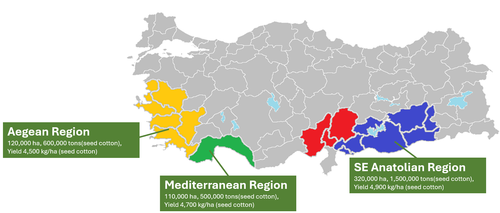 Regional distribution of cotton area, production, and yield in Turkey (seed cotton).
More recent official outlooks suggest the concentration has remained entrenched. Turkey’s agriculture research directorate (TEPGE) reported that in 2024, the Southeast Anatolia region accounted for 359,000 hectares of cotton out of a national 573,000 hectares—about 63% of Turkey’s total planted area, highlighting how decisively cotton has gravitated toward the irrigated southeast.
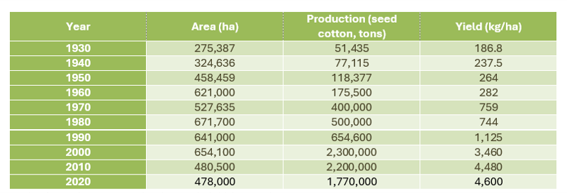 Turkey’s seed cotton production and yield (Source)
Cotton is not just a “thirsty” crop; it is structurally water-intensive. A WWF summary puts the global average at roughly 10,000–20,000 liters (rainfall plus irrigation) to produce 1 kilogram of cotton lint, while Better Cotton notes that the footprint varies widely by location and production system. That variability matters: when cotton is grown at scale in arid zones, irrigation becomes a continuous demand rather than a seasonal management problem.
In the Harran Plain, one of GAP’s flagship irrigation areas, published estimates place cotton’s irrigation water requirement at about 18,304 cubic meters per hectare under prevailing practices, versus about 13,765 cubic meters per hectare under a more efficient target scenario. Using the Southeast Anatolia region’s 2022/23 cotton area (359,000 hectares) as a proxy for the core GAP cotton belt, that implies roughly 6.57 billion cubic meters (6.57 BCM) of irrigation water requirement per year at current practice.
Set the cotton estimate against reported flows to transboundary countries, and the scale becomes easier to grasp. Iraqi officials have cited a benchmark of about 260 cubic meters per second reaching Iraq from upstream releases, roughly 8.20 BCM per year if sustained, while in 2025, Iraq’s water minister said only around 200 m³/s was reaching Haditha on the Euphrates, about 6.31 BCM per year, with the Tigris also near 200 m³/s. In effect, the water absorbed by GAP cotton is roughly comparable to a full year of Euphrates flow reaching Iraq at around 200 m³/s, and it amounts to about half of the combined Tigris–Euphrates volume.
Iraq relies heavily on water originating beyond its borders, and reductions in flow, especially during hot, dry months, translate quickly into stress on drinking water, farming, and ecosystems. The consequences become most visible at the end of the basins, around Basra and the Shatt al-Arab, where weakened river discharge accelerates saltwater intrusion. Human Rights Watch documented that at least 118,000 people were hospitalized in Basra in the summer of 2018 with symptoms linked to contaminated water, and since then, residents fearing “salt poisoning” as drought and upstream controls combine to worsen salinity.
The human toll is also showing up in mobility data. The International Organization for Migration’s displacement tracking has documented climate- and environment-related movement from southern rural areas, including villages and marsh-linked communities where livelihoods depend on farming, fishing, and livestock. In its March 2024 update, IOM recorded 23,364 families (140,184 individuals) still displaced by climatic and environmental factors, driven by drought, land degradation, and salinity, with Thi-Qar (44%) and Maysan (22%) as the leading areas of origin, followed by Muthanna (10%).
Turkey’s official position emphasizes a sovereign right to use water within its territory while avoiding “significant harm,” and treats the Tigris and Euphrates as transboundary rivers to be managed among riparian states. But the basin lacks a single, comprehensive, enforceable allocation framework comparable to those in some other river systems, leaving downstream countries exposed when infrastructure scales faster than diplomacy.
It would be misleading to blame Iraq’s water crisis on one crop alone. But cotton matters because it locks irrigation demand into the system. Once an irrigated economy reorganizes around a high-value crop, water releases are no longer only about electricity or general “development”; they become the operating condition for acreage, yields, and supply chains. In drought years, that can translate into tougher trade-offs downstream: less water reaching Iraq, rising salinity in the south, greater strain on farms, and mounting pressure on fragile ecosystems such as the Mesopotamian Marshes.